Details for Flight 1117898
| ModeS Hex Code | A441F5 |
|---|---|
| Registration | N37348 |
| Aircraft Type | 737MAX 8 B38M |
| Category | Jet |
| Operator |
United Airlines UAL  |
| Callsign | UAL1375 |
| First Seen | 2024-11-28 05:01:27 |
| First Altitude | 37000 ft |
| Last Seen | 2024-11-28 05:27:42 |
| Last Altitude | 35550 ft |
| Flight Status |
 Descending Descending |
| Number of Positions Reported | 167 |
| Possibly Landed At | |
| Published Route |
ICAO: KPHX–KEWR IATA: PHX–EWR Airports: Phoenix Sky Harbor to Newark Liberty Places: Phoenix, United States to Newark, United States |
| Tracking |
 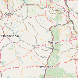      Leaflet © OpenStreetMap contributors |