Frequently Asked Questions
All commercial aircraft and many private planes are required to have a piece of electronic equipment called a transponder. Every transponder has a unique hex code associated with it; no two are the same. The transponder can be programmed by the pilot to broadcast a callsign, squawk code and altitude, all of which allow air traffic controllers to identify individual aircraft on their screens. This is called Mode-S and relies on ground-based radar to plot the position of the identified aircraft.
Newer technology, called ADS-B, exists to provide accurate identifier and position information for aircraft without the need of radar. ADS-B stands for Automatic Dependent Surveillance - Broadcast, and it is slowly being adopted by regulatory bodies and airlines around the world. The technology is widespread across Europe but is taking longer to adopt in North America.
With ADS-B, an aircraft can broadcast not only its callsign, squawk code and altitude, but it can also broadcast its exact latitude and longitude. Many commercially available (read: pricey) receivers exist to decode this data and represent it on a computer screen, but there are also many cheap ($20) USB dongles that can be plugged into a computer to do the same thing with the help of some free software. You can read more on my blog about how this is done.
My current setup employs the latter option, the cheap USB dongle – two of them, actually – to receive the Mode-S and ADS-B data from the aircraft that fly within a 200 nautical mile (more or less) radius from my location in Richmond Hill, Ontario, Canada. I then use a variety of different applications on my personal computer to decode the data into a human-readable form, display it on a screen, and store it in a database. Then a batch script extracts that data from the database and uploads it to this website for all of us to enjoy. Here is a breakdown of what the fields tell you on the Latest Flights page:
- FlightID is the unique number given to the flight record as it is stored in the database on personal computer. Clicking on this number will show you further details about that particular flight. See below for more information.
- Registration & Hex Code is the alphanumeric, human-readable identification of the aircraft and the unique hex code associated to the transponder in the aircraft. Clicking on either the registration or the hex code will display a list of other flights flown by the same aircraft.
- Aircraft Type is the manufacturer name and model type for the aircraft. The code in brackets is the four-digit ICAO code for that particular model.
- Operator is the name of the company operating the aircraft. This is not necessarily the name of the company that owns the plane, because many planes are leased by the airlines. The graphic is usually the logo of the airline but in some cases shows a silhouette of the shape of the aircraft.
- Callsign is the alphanumeric identifier for the flight, i.e. the air traffic control identification. This is not always entered correctly by the pilots, or the pilots may enter only a portion of the flight number. For example, Westjet pilots will sometimes enter just the number portion of the callsign without the WJA prefix that denotes their airline. Clicking on the callsign will display a list of other aircraft that have flown using the same callsign.
- Time Last Seen is the time my receiver last recorded data from the aircraft. This time is in the America/Eastern time zone, my local time.
- Possibly Landed is the airport at which I've calculated the aircraft might have landed. This requires the aircraft to be broadcasting it's correct latitude, longitude and altitude.
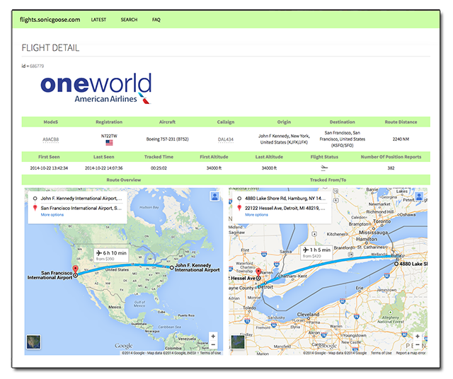
These are not the only fields available. As mentioned above, clicking on the unique Flight ID will bring up a page with further details about that flight. The page looks like this:

The additional fields displayed on this page are:
- First Seen is the time my receiver first recorded data from the aircraft. This time is in the America/Eastern time zone, my local time.
- First Altitude is the altitude, in feet, that was reported by the aircraft at the time it was First Seen.
- Last Altitude is the altitude, in feet, that was reported by the aircraft at the time it was Last Seen.
- Flight Status is an icon indicating whether the aircraft was ascending, descending, or flying level. There is a 500-foot tolerance in either direction.
- Number of Position Reports is the number of times the aircraft reported its position during the time it was being tracked by my receiver.
- Published Route is the last known route for the Callsign and lists the airports and cities of origin and destination.
- Tracked From/To is a Leaflet map, generated on the fly, showing a straight line between where the aircraft was First (green) and Last (red) Seen.
Acknowledgements
- Mario Trunz is an aviation enthusiast and web developer in Barrie, Ontario, Canada. Most of the code used to generate the original pages and tables at flights.sonicgoose.com was provided by him. He now runs his own aviation website, Aviation Flights, with details on most airframes built by major aircraft manufacturers.
- Christian Sorensen is an aviation enthusiast and database developer from Denmark. He contacted me by email after seeing my tutorials on sonicgoose.com. He and I brainstormed back and forth via email to create a SQL query that spanned multiple tables on multiple databases, and essentially formed the query I use to get the data on this site from my personal computer at home.